Ancient Highways of the Sea: The Maya and the Forgotten Canoe Routes to Florida and Easter Island
- Ishmael Bey

- Aug 3, 2025
- 7 min read
“There arrived a canoe full of Indians as long as a galley and eight feet wide; it was loaded with merchandise from the west, almost certainly from the land of the Yucatán.”
— Ferdinand Columbus, 1502 ( Christopher Columbus Son )

In an age when the so-called "New World" was still being mapped by European powers, one of the earliest and most powerful testimonies of trans-Gulf navigation came not from a Spanish admiral, but his son Ferdinand Columbus.
What he described was no ordinary canoe. This was a floating marketplace longer than a bus, eight feet wide, and loaded with finely woven cotton, copper bells, obsidian tools, cacao beans, and other luxury goods. Its origin? Almost certainly the Yucatán Peninsula homeland of the Maya.
And while Ferdinand saw this magnificent vessel off the coast of Honduras, the implications reach much farther all the way to Florida.
🌊 Ancient Mayan Maritime Power: Beyond the Jungle Temples
We often think of the Maya as landlocked people of pyramids and city-states deep in the jungles. But this overlooks one of their greatest achievements: ocean navigation.
The Maya weren’t just farmers and astronomers. They were seafarers, commanding large dugout canoes with the skill of any Mediterranean sailor. These canoes were capable of traveling hundreds of miles along coastlines and across the open sea.
With 20–25 trained rowers and a deep knowledge of currents, stars, and coastal markers, these vessels could travel from Belize to southern Florida in just 4 to 5 days. Not in theory but in reality.
Nautical Distance: Belize/Yucatán to Florida
Let’s look at approximate direct distances and apply speed estimates:
Route | Distance | Est. Duration @ 4 mph (nonstop) |
Belize City → Key West | ~435 miles | ~4.5 days |
Tulum (Yucatán) → Everglades | ~370 miles | ~3.9 days |
Cozumel → Tampa Bay | ~500 miles | ~5.2 days |
Bay of Honduras → Cape Sable | ~400 miles | ~4.2 days |
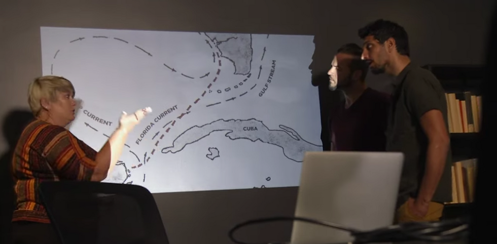
Gulf Currents and a Natural Highway
Modern oceanographic maps reveal what Indigenous navigators already knew: the Yucatán Current, which becomes the Loop Current, flows directly into the Gulf of Mexico, sweeping north toward the coast of Florida.
A skilled Maya trader could have launched from Belize, curved with the current past Cuba, and reached the Everglades, Tampa Bay, or the Calusa strongholds on Florida’s west coast with remarkable efficiency. These were not accidental drifters. These were intentional navigators, riding a current that acted as a natural highway between continents.
Factor | Evidence |
Maya canoe speed | ~4–5 mph, proven feasible with >20 rowers |
Distance Belize → Florida | ~370–500 miles |
Duration | 4–5 days (nonstop or with short layovers) |
Navigation | Stellar, memory-based, coastal, and current-assisted |
Spanish confirmation | Descriptions of huge Maya trade canoes off Honduras and Yucatán |
Modern evidence | Ethnographic use, experimental voyages, archaeological finds |
Natural water currents can take you from Belize to Florida in 4 days
Florida Was Not a Dead End It Was a Market
In Florida, archaeologists have uncovered clues of a much larger trade network than previously imagined:
Copper bells of Mesoamerican origin have turned up in Calusa and Timucua territories.
Obsidian tools chemically matched to Guatemala found in elite southeastern burials.
Canoe-building traditions and ceremonial art echo styles known from the Maya world.
And the Spanish confirmed it. When Pedro Menéndez de Avilés landed in Florida, he found coastal peoples already navigating and trading with nearby islands and regions to the south. He wasn’t introducing seafaring, he was interrupting it.
What History Forgot Or Chose to Ignore
Why don’t we hear more about this in textbooks?
Because it breaks the colonial narrative. The idea of advanced, ocean faring Indigenous civilizations connecting across the Gulf long before Columbus challenges the myth that the Americas were isolated, primitive, or unconnected. It forces us to rethink the borders of civilizations.
It shows us that Florida wasn’t the end of the Maya world, it may have been part of its edge.
Arriving in Florida

What Ferdinand Columbus Saw Was Just the Beginning
That single canoe, seen in 1502, was more than an impressive vessel. It was a living artifact of a transcontinental world one made by Indigenous hands, mapped by oral memory, and sustained through centuries of commerce and culture.
Florida was not unknown to the Maya. It was reachable, tradeable, and likely visited. The evidence may be scattered, but the story is coming together in obsidian, copper, cacao... and canoes.
And now, 500 years later, we’re finally listening to what the winds, the currents, and Ferdinand Columbus tried to tell us.
Canoes, Trade & DNA: The American Indian Connection to Easter Island
For centuries, mainstream history taught us that the Americas and the Pacific Islands were isolated worlds separated by thousands of miles of water, culture, and time. But what happens when science, Indigenous knowledge, and ancient maritime skill tell a different story?
The truth is becoming undeniable:
Canoes, trade, and DNA have linked the American Indian peoples with Easter Island and it’s rewriting everything we thought we knew about human migration.
🛶 Canoes That Crossed Oceans
Indigenous peoples of the Americas including the Maya, Chumash, Mapuche, and other coastal nations were not stranded in their territories. They were seafarers. And across the Pacific, the Polynesians were legendary for their open-ocean navigation using double-hulled canoes, stars, currents, and wind patterns.
But what many don’t realize is this:
The Pacific Ocean wasn’t a barrier. It was a highway.
Canoes, not caravels, were the first transoceanic vehicles.
It’s now documented that Polynesian voyagers reached South America before Europeans arrived and likely traded with American Indian peoples. Some researchers argue that the exchange went both directions.
DNA Doesn’t Lie: The Genetic Link to South America
In a groundbreaking 2020 study published in Nature, researchers compared genomes of modern and ancient populations. The finding?
Polynesians specifically from Easter Island (Rapa Nui) share genetic markers with Indigenous peoples of northern South America, including Colombia and Ecuador.
This indicates interbreeding that occurred before European colonization, dated as early as AD 1150–1230.
This predates Columbus by 250–300 years.
It proves direct contact not accidental driftwood stories, but intentional travel.
🔗 Source: Ioannidis et al., Nature, “Native American gene flow into Polynesia predating Easter Island settlement” (2020)
Sweet Potatoes, Chickens, and Shared Crops
Before the DNA came the botanical clues:
The sweet potato (Ipomoea batatas), native to South America, was found across Polynesia with no European mediation.
Chickens and certain canoe designs also share traits between South America and Polynesia.
Early carbon dating showed these crops were present hundreds of years before the Spanish or Portuguese touched either region.
This means American Indian agricultural knowledge was literally crossing the sea.
Bonus Link :
The Sweet Potato: 1492

From Sweet Potatoes to DNA: New Evidence Supports Links Between South American and Polynesian Cultures https://ssec.si.edu/stemvisions-blog/sweet-potatoes-dna-new-evidence-supports-links-between-south-american-and
American Indians Arriving at Easter Island

🗿 What Does This Mean for Easter Island?
Easter Island (Rapa Nui) is the easternmost inhabited Polynesian island and the closest to the Americas. Oral histories from Polynesians speak of voyages to a "big land to the east" often dismissed by academics.
But now?
Their legends match the DNA
The canoes match the currents
The timeline fits the archaeological record
Some anthropologists and Indigenous researchers believe that South American canoe peoples, potentially from the Mapuche, Quechua, or even North American tribes using coastal trade reached or received Polynesians in return.
American Indian Seafaring Isn’t a Myth It’s a Missing Chapter
The Maya had trans-Gulf maritime networks.
The Chumash of California crafted advanced plank canoes (tomol) and were known to island-hop the Channel Islands.
The Yaghan and Mapuche navigated the stormy southern Pacific using hide-covered canoes and could easily link with Polynesian currents.
Together, this shows us one truth:
American Indians weren’t isolated. They were part of a Pacific World.
it is far easier, shorter, and more geographically and oceanographically feasible for the Maya to reach Florida than Easter Island — and yet, mainstream history is quicker to accept Polynesian contact with South America than it is to accept Maya or American Indian contact with Florida.
Let’s break it down clearly, point by point:
Route | Distance | Navigation Type |
Belize / Yucatán → Florida Keys | ~400–500 miles | Coastal / open-sea |
Cozumel → Cape Sable / Everglades | ~380 miles | Assisted by Loop Current |
Estimated Travel Time | 4–5 days by canoe | With 20+ rowers at ~4 mph |
Currents assist: Yucatán → Loop Current → Gulf → Florida
Land visible most of the way
Trade incentives: Salt, obsidian, cacao, cotton
Spanish accounts confirm canoe size and range
No need for sails, celestial navigation optional
❌ Maya to Easter Island
Route | Distance | Navigation Type |
Guatemala → Easter Island (Rapa Nui) | ~2,600+ miles | Open-ocean, no landmarks |
Requires | Advanced sailing canoes | No documented Maya vessels of this size/scope |
Travel Time | Weeks to months | Needs food, water, and celestial nav |
No assisting currents directly from Central America
Requires Polynesian-style voyaging canoes
No archaeological record of Maya venturing this far
Would need either Polynesians sailing east or extreme outlier voyages
So Why the Double Standard?
Historians and scientists are willing to accept DNA contact between Polynesians and South Americans, but often dismiss direct Maya–Florida contact that:
Is shorter and easier
Has more written documentation (Ferdinand Columbus)
Matches archaeological evidence (trade goods in Florida)
Fits existing canoe and navigation technology
Aligns with Gulf current flows and island-hopping routes via Cuba
🚨 Key Point: If Polynesians could reach South America via Easter Island, then Maya reaching Florida — just across a loop current — is not just possible, it’s probable.
🛶 Why Florida Was a Logical Maya Trade Target
Florida’s coastal tribes (Calusa, Tequesta, Timucua) were skilled mariners
Canoe technology in Florida was comparable to Maya longboats
Coastal Florida had valuable marine resources, shells, fish, and strategic positioning
Florida was part of a larger Indigenous trade network stretching into the Caribbean and Central America
If you can accept a trans-Pacific journey from Polynesia to South America Then you must absolutely accept a Gulf voyage from the Maya to Florida.
One is 2,600 miles of open ocean with no visibility of land. The other is 400–500 miles of current-assisted travel with documented historical sightings, canoe technology, and archaeological artifacts to back it up.
The real question isn't if the Maya reached Florida.
The question is — why is this so rarely taught?


Comments